Product
Data Citadel
LocationMind Data Citadel is a geospatial data processing platform that turns raw mobility data into reliable, analysis-ready information. Mobility data shows how people and vehicles move and interact across different places, and Data Citadel integrates the validation, processing, monitoring and delivery of that data within a single platform.
Data Citadel connects project requirements with input datasets, configurable geospatial pipelines and validated outputs through a structured request workflow. Data Engineers can review inputs, execute and monitor each processing step, investigate failures, and trace data lineage from the original source through to the resulting geospatial datasets.
The pipelines are reusable and the architecture is extensible, so one foundation serves evolving mobility data needs and the outputs are ready for analysis and visualization in the BI tools a project already uses.
Data Citadel Features
-
1
Structured Data Requests
Converts project requirements into trackable requests containing required inputs, processing needs, and expected outputs.
-
2
Reusable Geospatial Pipelines
Supports configurable workflows for cleaning, transforming, map-matching, segmenting, and aggregating mobility data.
-
3
Centralized Workflow Orchestration
Coordinates pipeline stages within one managed process, from input preparation through output generation.
-
4
Execution Monitoring and Recovery
Provides step-level status and logs so Data Engineers can identify failures, correct problems, and rerun processing.
-
5
Data Lineage and Output Management
Connects source data, configurations, executions, and validated outputs, making results traceable and reusable.
Data Citadel Workflow Demonstration
How Data Citadel fits together
-
Platform Overview
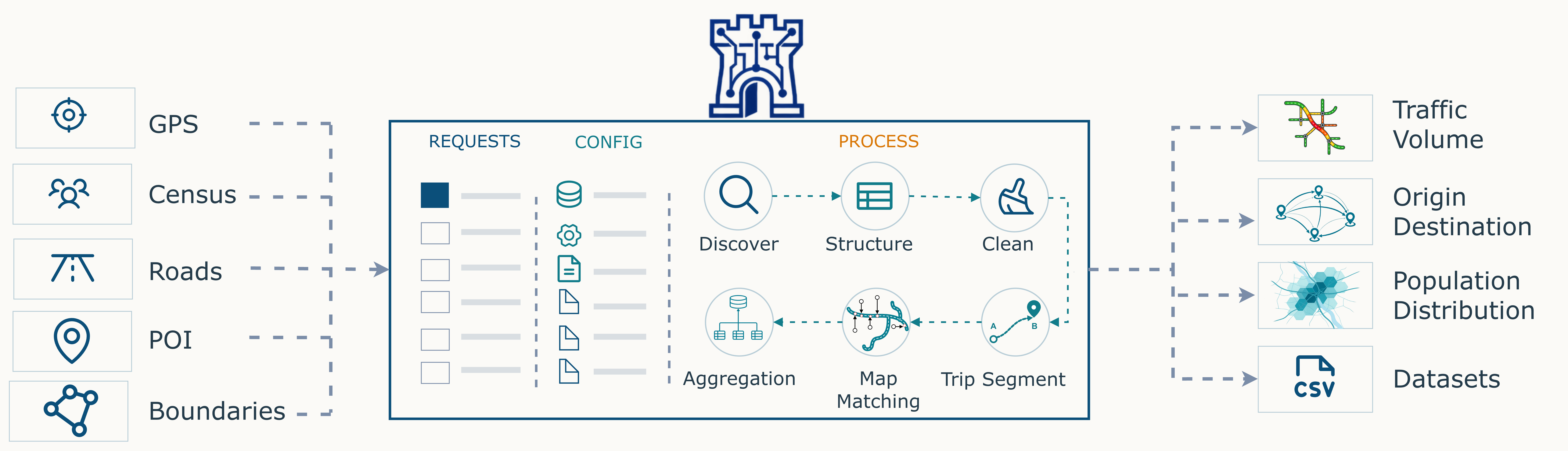
Geospatial inputs enter the platform and leave as datasets, trajectories, map layers and output files.
-
Why It Matters
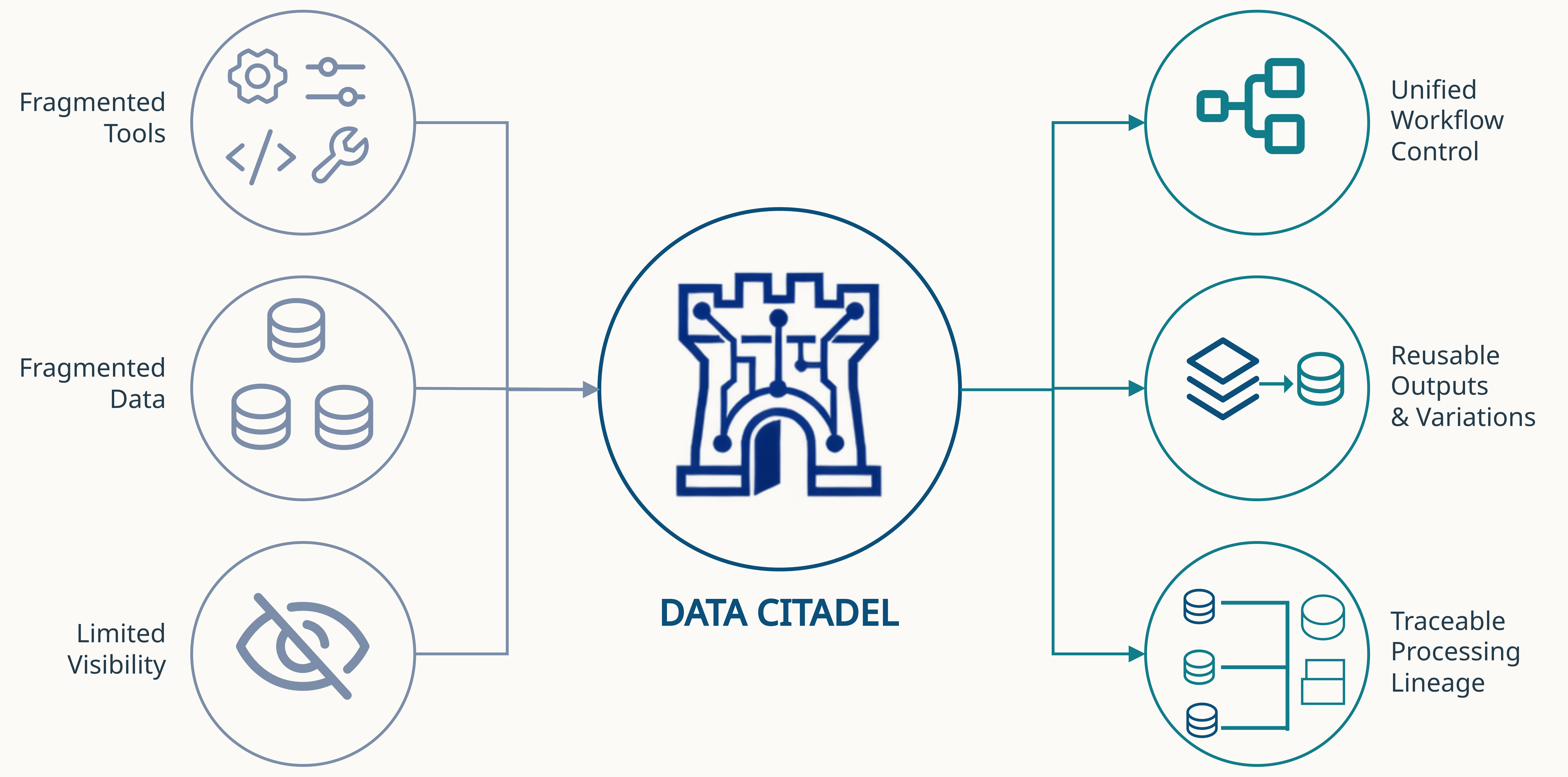
Fragmented tools and limited visibility give way to one unified, traceable workflow.
-
How It Works
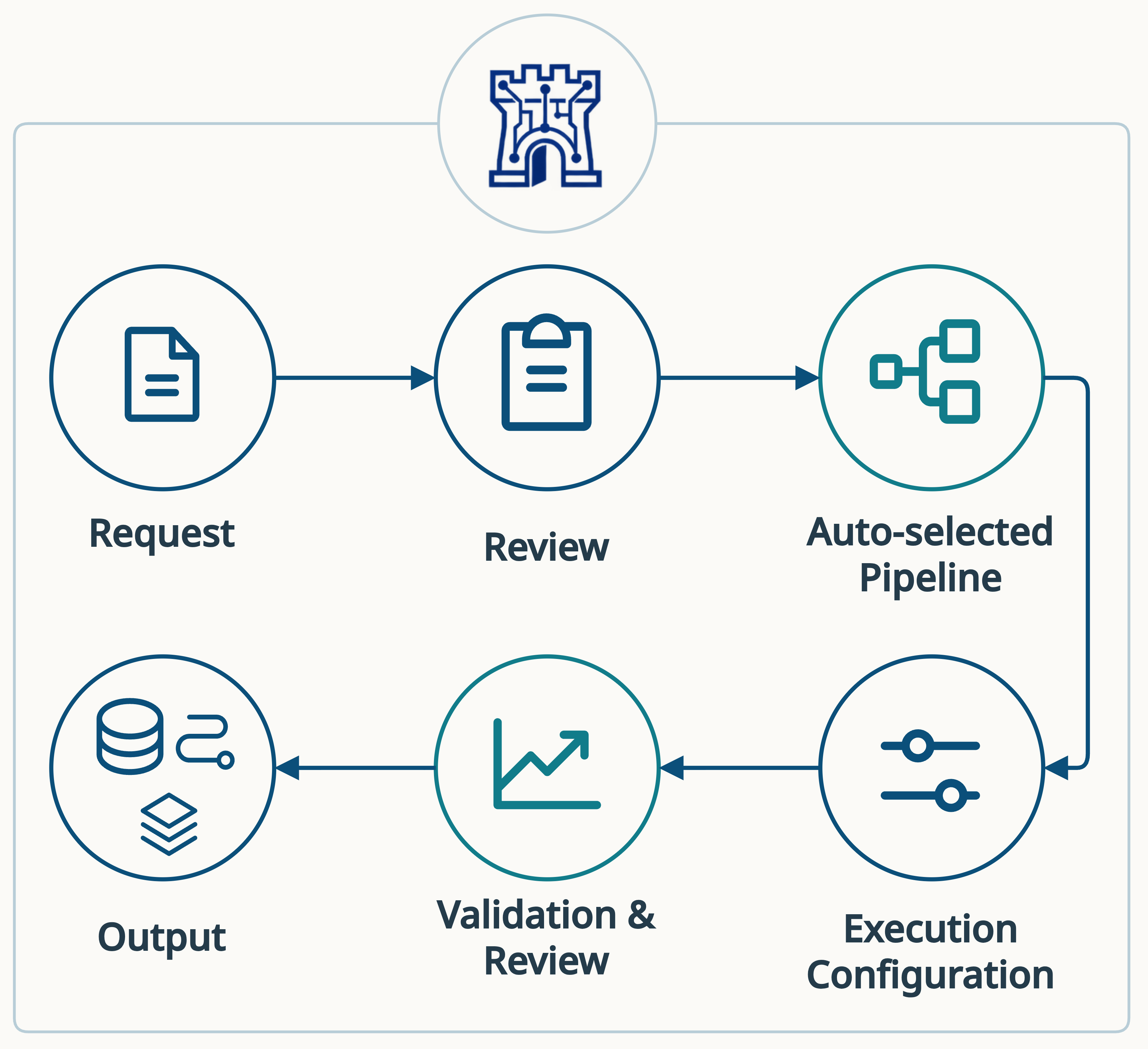
The capabilities that surround a request, from input preparation through to a validated output.
- Request
- Configure
- Review
- Process
- Monitor
- Output
Various scenes of Data Citadel
- Disaster Management Know how many people are in a hazard zone and which way they move during a response.
- Tourism & Footfall Analysis See where visitors come from, where they go next, and how busy each place gets.
- Dynamic Population & Migration Follow how population is distributed across an area and how it shifts over time.
- Traffic Congestion Analysis Measure how much traffic a road carries, and how slowly it is moving.
- Urban & Transport Planning Plan districts and networks on how they are actually used across the day, week and season.
- Epidemic Spread Analysis Trace how movement between areas can carry the spread of a disease.
Supported data pipelines
-
Available now
Mobile GPS Data
- Disaster management
- Tourism and footfall analysis
- Dynamic population and migration analysis
-
Future pipeline
Vehicle Probe Data
- Traffic congestion analysis
- Urban transport planning
- Carbon emissions estimation
-
Future pipeline
Call Detail Record Data
- Transport master planning
- Dynamic Census
- Epidemic spread analysis
The listed items are potential application areas. Mobile GPS processing is the currently available pipeline; vehicle probe and call detail record processing describe the platform’s future direction.
Discover how Data Citadel can support reusable and traceable mobility data processing.
FAQ
- ● What is Data Citadel?
- Data Citadel is LocationMind’s geospatial data processing platform for turning raw mobility data into processed, analysis-ready geospatial datasets. It brings data requests, reusable processing pipelines, execution monitoring and output review together in one place, so a project team can follow a dataset from its original source through to the final output.
- ● What is a GPS data source?
- GPS data refers to timestamped location information that captures how people and vehicles move. The location data consists of geographic coordinates (latitude and longitude) and does not contain personally identifiable information. Data Citadel takes this raw anonymized data as input and cleans, processes, transforms and aggregates it using LocationMind’s proprietary data-processing techniques to produce datasets ready for analysis and visualization.
- ● Who runs the processing, and what happens if a step fails?
- Data Engineers start the workflows and monitor each processing step. When something goes wrong, the step-level status and logs make it possible to identify the step that failed, troubleshoot it and re-run the work. Results are reviewed before they are treated as final.
- ● Can we have a pipeline configured for our own requirements?
- Yes. A mobility data requirement is turned into a structured request, the necessary input data is identified and reviewed, and an appropriate processing pipeline is prepared for it. If you would like to discuss a specific requirement, you may contact us here.
- ● Which mobility data sources are supported?
- Mobile GPS processing is the pipeline available today. The architecture is reusable and extensible, and vehicle probe and call detail record processing describe where the platform is heading.
- ● Is there a trial version?
- Please register here with us here and we will contact you as soon as the service is available.
- ● What is the introduction price of Data Citadel?
- For more information, please contact us.